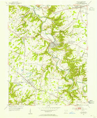
1953 Map of Batavia
USGS Topo · Published 1955About this map
The East Fork Little Miami River carves a deep valley through the center of this mid-century survey, anchoring the village of Batavia. The landscape reflects a mix of traditional rural infrastructure and emerging post-war leisure, evidenced by the presence of a Covered Bridge alongside a modern Drive-in Theater near Mt Holly. The Norfolk and Western railroad corridor dictates the settlement patterns north of the river, connecting Owensville and Willowville.
Find a feature on this map
45 named features on this map. Tap any name to fly to it.
Don’t see what you’re looking for? This feature index may not catch every label — zoom into the map to look around manually.
Map Details
Editions of this 1953 Batavia Map
This is the sole edition of this map. No revisions or reprints were ever made.
Other maps of this area

1898 · East Cincinnati
USGS Topo · 1:62,500

1914 · East Cincinnati
USGS Topo · 1:62,500

1914 · Batavia
USGS Topo · 1:48,000

1916 · Batavia
USGS Topo · 1:62,500

1929 · Alexandria
USGS Topo · 1:48,000

1931 · Felicity
USGS Topo · 1:62,500

1936 · Alexandria
USGS Topo · 1:62,500

1953 · Laurel
USGS Topo · 1:24,000

1953 · Withamsville
USGS Topo · 1:24,000

1953 · Bethel
USGS Topo · 1:24,000