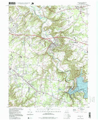
1996 Map of Batavia
USGS Topo · Published 1999About this map
The East Fork Little Miami River carves a deep valley through this Clermont County landscape, anchored by the village of Batavia. By the mid-1990s, the southern reaches are dominated by the extensive waters of William H Harsha Lake and the recreational lands of East Fork State Park. The map reveals a suburbanizing character, with clusters of development at Amelia, Willowville, and Owensville connected by historical routes like Jackson Pike and Clough Pike.
Find a feature on this map
47 named features on this map. Tap any name to fly to it.
Don’t see what you’re looking for? This feature index may not catch every label — zoom into the map to look around manually.
Map Details
Editions of this 1996 Batavia Map
This is the sole edition of this map. No revisions or reprints were ever made.
Other maps of this area

1898 · East Cincinnati
USGS Topo · 1:62,500

1914 · East Cincinnati
USGS Topo · 1:62,500

1914 · Batavia
USGS Topo · 1:48,000

1916 · Batavia
USGS Topo · 1:62,500

1929 · Alexandria
USGS Topo · 1:48,000

1931 · Felicity
USGS Topo · 1:62,500

1936 · Alexandria
USGS Topo · 1:62,500

1953 · Laurel
USGS Topo · 1:24,000

1953 · Withamsville
USGS Topo · 1:24,000

1953 · Bethel
USGS Topo · 1:24,000