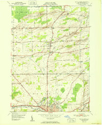
1951 Map of Batavia North
USGS Topo · Published 1951About this map
The industrial and agricultural landscape of Genesee County unfolds across this mid-century survey, centered on the northern expansion of Batavia and the village of Elba. The southern portion of the map is dominated by the city's civic and medical infrastructure, including the State School For the Blind, Veterans Hospital, and Genesee Memorial Hospital. North of the city, the terrain transitions into the fertile but wet mucklands of the Oak Orchard Swamp and Batavia Swamp, separated by the prominent elevation of Bulgary Ridge. The New York Central railroad cuts through this rural landscape, connecting small outposts like East Oakfield, Langton Corners, and Five Corners. Local history and genealogy interest is high throughout, with several burial grounds such as Maplewood Cem and Gardner Cem recorded alongside the winding course of Tonawanda Creek.
Find a feature on this map
68 named features on this map. Tap any name to fly to it.
Don’t see what you’re looking for? This feature index may not catch every label — zoom into the map to look around manually.
Map Details
Editions of this 1951 Batavia North Map
This is the sole edition of this map. No revisions or reprints were ever made.
Other maps of this area

1897 · Albion
USGS Topo · 1:62,500

1897 · Medina
USGS Topo · 1:62,500

1904 · Batavia
USGS Topo · 1:62,500

1905 · Attica
USGS Topo · 1:62,500

1944 · Alexander
USGS Topo · 1:31,680

1944 · Holley
USGS Topo · 1:31,680

1944 · Byron
USGS Topo · 1:31,680

1944 · Stafford
USGS Topo · 1:31,680

1944 · Albion
USGS Topo · 1:31,680

1949 · Attica
USGS Topo · 1:62,500