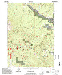
1996 Map of Bates
USGS Topo · Published 1998About this map
Malheur National Forest dominates this mid-1990s survey, illustrating a landscape defined by timber, water management, and high-elevation passage. The Middle Fork John Day River cuts across the northern terrain, feeding industrial and natural features like the Log Pond and Bates Pond near the settlement of Bates. These water bodies and nearby sites like the Quarry and Gravel Pit reflect the area's resource-based economy during this era. High-altitude points such as Dixie Butte and the Dixie Summit pass underscore the region's topographical challenges for travelers on the Long Prairie Creek Rd. The presence of the Ranger District headquarters and a network of springs, including Dixie Spring and Huckleberry Spring, highlights the active federal management of these public lands for both conservation and recreational use.
Find a feature on this map
33 named features on this map. Tap any name to fly to it.
Don’t see what you’re looking for? This feature index may not catch every label — zoom into the map to look around manually.
Map Details
Editions of this 1996 Bates Map
This is the sole edition of this map. No revisions or reprints were ever made.
Other maps of this area

1901 · Sumpter
USGS Topo · 1:125,000

1908 · Ironside Mountain
USGS Topo · 1:125,000

1951 · Bates
USGS Topo · 1:62,500

1955 · Canyon City
USGS Topo · 1:250,000

1959 · Canyon City
USGS Topo · 1:250,000

1959 · Prairie City
USGS Topo · 1:62,500

1972 · Austin
USGS Topo · 1:24,000
1972 · Deardorff Mtn
USGS Topo · 1:24,000

1972 · Greenhorn
USGS Topo · 1:24,000

1978 · John Day
USGS Topo · 1:100,000