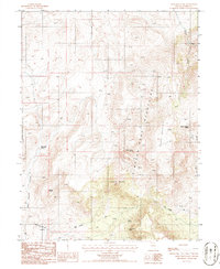
1986 Map of Bates Mountain
USGS Topo · Published 1986About this map
The Simpson Park Mountains dominate this high-desert landscape in Lander County during the mid-1980s. A significant historical corridor is preserved here in the form of the Old Pony Express Trail, which cuts across the southern portion of the quadrangle, south of Eagle Butte. The terrain is defined by its water sources, with numerous named points such as Indian Ranch Spring, Bates Mountain Spring, and Bullrush Spring serving as vital landmarks in an otherwise arid environment. Along the western edge, the map reaches into the Toiyabe National Forest near Rye Patch Canyon. This survey captures a moment when traditional land use—indicated by cattle ranching relics like Indian Ranch Spring—coexisted with modern infrastructure, such as the Wooden Pole Trans Line and its associated substation.
Find a feature on this map
22 named features on this map. Tap any name to fly to it.
Don’t see what you’re looking for? This feature index may not catch every label — zoom into the map to look around manually.
Map Details
Editions of this 1986 Bates Mountain Map
This is the sole edition of this map. No revisions or reprints were ever made.
Other maps of this area

1926 · Roberts Mountains
USGS Topo · 1:250,000

1929 · Roberts Mountains
USGS Topo · 1:250,000

1955 · Millett
USGS Topo · 1:250,000

1956 · Mount Callaghan
USGS Topo · 1:62,500

1956 · Ackerman Canyon
USGS Topo · 1:62,500

1959 · Millett
USGS Topo · 1:250,000

1960 · Hickison Summit
USGS Topo · 1:62,500

1960 · Spencer Hot Springs
USGS Topo · 1:62,500

1978 · Summit Mountain
USGS Topo · 1:100,000

1979 · Simpson Park Mtns
USGS Topo · 1:100,000