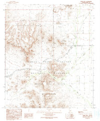
1990 Map of Bates Well
USGS Topo · Published 1990About this map
Bates Well stands as a vital watering point at the intersection of several desert valleys, anchoring a landscape defined by the convergence of the Cabeza Prieta National Wildlife Refuge and the Organ Pipe Cactus National Monument. This 1990 provisional survey records a region where survival once depended on such isolated wells and the mineral promise found in the high ground. Mining activity is prevalent throughout the Growler Mountains, with specific sites like the Bluebird Mine, Scarface Mountain, and numerous prospects and open pit mines scattered across the ridgelines. The terrain is bisected by seasonal drainage systems including Growler Canyon and Cuerda de Le na Wash. Evidence of early cattle ranching or transport is visible through features like the Bandeja Well and its adjacent Corral, connected by the unpaved Bates Well Road.
Find a feature on this map
32 named features on this map. Tap any name to fly to it.
Don’t see what you’re looking for? This feature index may not catch every label — zoom into the map to look around manually.
Map Details
Editions of this 1990 Bates Well Map
This is the sole edition of this map. No revisions or reprints were ever made.
Other maps of this area

1932 · Ajo
USGS Topo · 1:62,500

1934 · Ajo
USGS Topo · 1:62,500

1953 · Ajo
USGS Topo · 1:250,000

1957 · Ajo
USGS Topo · 1:250,000

1958 · Ajo
USGS Topo · 1:250,000

1962 · Ajo
USGS Topo · 1:250,000

1963 · Ajo
USGS Topo · 1:250,000

1963 · Ajo
USGS Topo · 1:62,500

1963 · Kino Peak
USGS Topo · 1:62,500

1964 · Growler Peak
USGS Topo · 1:62,500