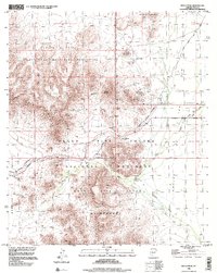
1996 Map of Bates Well
USGS Topo · Published 2000About this map
Bates Well sits at the junction of the Bates Well Road and a 4WD track, serving as a rare point of human infrastructure in this arid corridor of Pima County. The map documents a landscape where resource extraction and conservation meet, with numerous prospects and mines dotting the slopes near Lime Hill and Scarface Mountain. The industrial footprint of the Bluebird Mine contrasts with the surrounding protected lands of the Cabeza Prieta National Wildlife Refuge and the Organ Pipe Cactus National Monument. A network of dry washes, including Cuerda de Lena Wash and Growler Wash, dictates the movement across the Ajo Valley. Notable landmarks like the John the Baptist Mountains and the strategic Growler Pass provide the primary navigational relief in a region defined by its isolation and specialized desert ecology.
Find a feature on this map
35 named features on this map. Tap any name to fly to it.
Don’t see what you’re looking for? This feature index may not catch every label — zoom into the map to look around manually.
Map Details
Editions of this 1996 Bates Well Map
This is the sole edition of this map. No revisions or reprints were ever made.
Other maps of this area

1932 · Ajo
USGS Topo · 1:62,500

1934 · Ajo
USGS Topo · 1:62,500

1953 · Ajo
USGS Topo · 1:250,000

1957 · Ajo
USGS Topo · 1:250,000

1958 · Ajo
USGS Topo · 1:250,000

1962 · Ajo
USGS Topo · 1:250,000

1963 · Ajo
USGS Topo · 1:250,000

1963 · Ajo
USGS Topo · 1:62,500

1963 · Kino Peak
USGS Topo · 1:62,500

1964 · Growler Peak
USGS Topo · 1:62,500