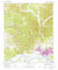
1943 Map of Batesville
USGS Topo · Published 1978About this map
Batesville sits at the heart of this mid-century landscape, positioned north of the White River where the Missouri Pacific railroad branches through the valleys. The map illustrates a transitional economy, balancing the urban center of Batesville with outlying industrial sites like the Scheid Quarry, the Barron Mine, and the Miller-Rhinehart Washer. Along the river's winding path, Earnheart Island and Luster Island sit near the mouth of the Simpson Slough, while Ruddell Lake and Lake Unico reflect the hydrology of the lowlands.
Find a feature on this map
58 named features on this map. Tap any name to fly to it.
Don’t see what you’re looking for? This feature index may not catch every label — zoom into the map to look around manually.
Map Details
Editions of this 1943 Batesville Map
4 editions found

Other maps of this area

1890 · Batesville
USGS Topo · 1:125,000

1891 · Batesville
USGS Topo · 1:125,000

1942 · Bethesda
USGS Topo · 1:24,000

1942 · Jamestown
USGS Topo · 1:31,680

1942 · Almond
USGS Topo · 1:31,680

1942 · Salado
USGS Topo · 1:31,680

1942 · Batesville
USGS Topo · 1:31,680

1942 · Mt Pleasant
USGS Topo · 1:31,680

1943 · Sandtown
USGS Topo · 1:24,000

1943 · Cave City
USGS Topo · 1:31,680