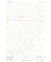
1954 Map of Bath
USGS Topo · Published 1978About this map
The James River meanders through the eastern edge of this South Dakota landscape, defining the agricultural character of Bath and Gem townships. This 1954 topography, updated with revisions from 1975, captures the mid-century development of Bath and Bath Corner along the Chicago Milwaukee St Paul and Pacific railroad line. The map highlights the essential local infrastructure of the era, from the Hunstad Sch and Aberdeen Range Station to a designated Trailer Park. A significant portion of the road network is noted as Under Construction in the mid-1970s updates, indicating a period of active transportation expansion across the prairie. The presence of the German Cem and a central village Cem offers valuable markers for those researching the early families who settled the James River valley.
Find a feature on this map
13 named features on this map. Tap any name to fly to it.
Don’t see what you’re looking for? This feature index may not catch every label — zoom into the map to look around manually.
Map Details
Editions of this 1954 Bath Map
2 editions found
Other maps of this area

1894 · Columbia
USGS Topo · 1:62,500

1895 · Aberdeen
USGS Topo · 1:125,000

1896 · Columbia
USGS Topo · 1:125,000

1952 · Columbia
USGS Topo · 1:24,000

1952 · Ordway
USGS Topo · 1:24,000

1952 · Putney
USGS Topo · 1:24,000

1953 · Stratford
USGS Topo · 1:24,000

1953 · Groton SW
USGS Topo · 1:24,000

1953 · Warner
USGS Topo · 1:24,000

1954 · Bath
USGS Topo · 1:24,000