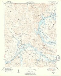
1949 Map of Bath Springs
USGS Topo · Published 1952About this map
The Tennessee River winds through this 1949 survey, defining a landscape of deep bends and active river landings just as Kentucky Lake reshaped the valley. The map documents a riverside economy transitioning from traditional furnace works and landings to a flooded valley, with industrial traces like the Ore furnace near Akin Landing still visible. The terrain is marked by ridges such as Phillip Ridge and Backbone Ridge, which hem in small settlements like Bath Springs and Campbell.
Find a feature on this map
174 named features on this map. Tap any name to fly to it.
Don’t see what you’re looking for? This feature index may not catch every label — zoom into the map to look around manually.
Map Details
Editions of this 1949 Bath Springs Map
3 editions found
Other maps of this area

1905 · Waynesboro
USGS Topo · 1:125,000

1936 · Hookers Bend
USGS Topo · 1:24,000

1936 · Scotts Hill
USGS Topo · 1:24,000

1936 · Eagle Creek
USGS Topo · 1:24,000

1936 · Thurman
USGS Topo · 1:24,000

1936 · Olivehill
USGS Topo · 1:24,000

1936 · Bath Springs
USGS Topo · 1:24,000

1936 · Clifton
USGS Topo · 1:24,000

1936 · Perryville
USGS Topo · 1:24,000

1936 · Pope
USGS Topo · 1:24,000