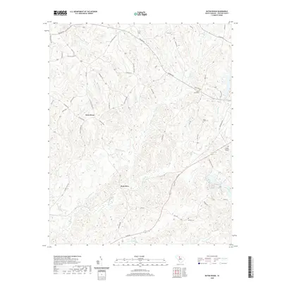
2020 Map of Baton Rouge
USGS Topo · Published 2020About this map
Baton Rouge and the surrounding Chester County uplands are defined by a dense network of creek valleys and ridges that have shaped local settlement for generations. The landscape is heavily dissected by the Sandy River and its numerous tributaries, including Gum Spring Br, Bond Br, and Walkers Mill Br, which flow through the timbered hills. This modern survey captures the rural character of the region, where family and community heritage is preserved in sites like Grant Cem, Mount Moriah Cem, and the Old Zion Cem near the southern edge. The distribution of homes along roads like Pinckney Rd and W Chester School Rd reflects a long-standing pattern of ridge-top living above the marshy bottoms of the Little Sandy River and Julies Fork. For the local historian, the map provides a clear look at how contemporary development centers around traditional nodes like Sandy River and the well-tended grounds of Chester Memorial Gardens.
Find a feature on this map
63 named features on this map. Tap any name to fly to it.
Don’t see what you’re looking for? This feature index may not catch every label — zoom into the map to look around manually.
Map Details
Editions of this 2020 Baton Rouge Map
This is the sole edition of this map. No revisions or reprints were ever made.
Other maps of this area

1907 · Sharon
USGS Topo · 1:62,500

1941 · Spartanburg
USGS Topo · 1:250,000

1949 · Rock Hill
USGS Topo · 1:62,500

1953 · Spartanburg
USGS Topo · 1:250,000

1960 · Spartanburg
USGS Topo · 1:250,000

1963 · Spartanburg
USGS Topo · 1:250,000

1964 · Spartanburg
USGS Topo · 1:250,000

1968 · Blackstock
USGS Topo · 1:24,000
1969 · Carlisle
USGS Topo · 1:24,000

1969 · Baton Rouge
USGS Topo · 1:24,000