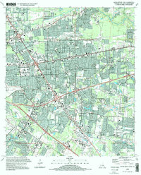
1995 Map of Baton Rouge East
USGS Topo · Published 1998About this map
Baton Rouge expands eastward in this mid-1990s record of rapid suburbanization across East Baton Rouge Parish. The map reveals an intricate network of residential neighborhoods like Red Oak, Broadmoor, and Goodwood filling the spaces between established thoroughfares like Florida Blvd and Jefferson Highway. Institutional growth is evident in the concentration of medical and educational facilities, including the sprawling Our Lady of the Lake Regional Medical Center and the LSU Rural Life Museum.
Find a feature on this map
150 named features on this map. Tap any name to fly to it.
Don’t see what you’re looking for? This feature index may not catch every label — zoom into the map to look around manually.
Map Details
Editions of this 1995 Baton Rouge East Map
This is the sole edition of this map. No revisions or reprints were ever made.
Other maps of this area

1906 · Bayou Sara
USGS Topo · 1:125,000

1908 · Baton Rouge
USGS Topo · 1:62,500

1934 · Denham Springs
USGS Topo · 1:62,500

1939 · Zachary
USGS Topo · 1:62,500

1939 · Denham Springs
USGS Topo · 1:62,500

1939 · Baton Rouge
USGS Topo · 1:62,500

1942 · Watson
USGS Topo · 1:31,680

1953 · Baton Rouge West
USGS Topo · 1:24,000

1953 · Plaquemine
USGS Topo · 1:24,000

1953 · St. Gabriel
USGS Topo · 1:24,000