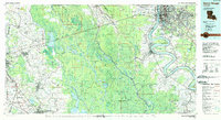
1984 Map of Baton Rouge
USGS Topo · Published 1984About this map
The Mississippi River snake-like meander dominates the eastern portion of this 1984 survey, defining the industrial and urban corridor from Baton Rouge down through Plaquemine and Donaldsonville. West of the river, the landscape transitions into the massive Atchafalaya Basin Floodway, a complex network of wetlands and waterways including Grand Lake and Lake Fausse Pointe. This area illustrates the critical engineering required to manage the state's hydraulic systems, notably the Intracoastal Waterway and various levees protecting the low-lying terrain.
Find a feature on this map
58 named features on this map. Tap any name to fly to it.
Don’t see what you’re looking for? This feature index may not catch every label — zoom into the map to look around manually.
Map Details
Editions of this 1984 Baton Rouge Map
2 editions found
Other maps of this area

1892 · Donaldsonville
USGS Topo · 1:62,500

1892 · Thibodaux
USGS Topo · 1:62,500

1906 · Bayou Sara
USGS Topo · 1:125,000

1908 · Baton Rouge
USGS Topo · 1:62,500

1927 · Thibodaux NW
USGS Topo · 1:31,680

1932 · Abbeville NE
USGS Topo · 1:31,680

1934 · Denham Springs
USGS Topo · 1:62,500

1935 · Gonzales
USGS Topo · 1:31,680

1935 · Osca Bayou
USGS Topo · 1:62,500

1935 · Chicot Lake
USGS Topo · 1:62,500