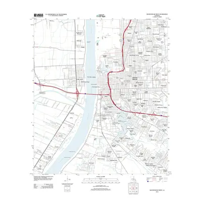
2012 Map of Baton Rouge West
USGS Topo · Published 2012About this map
The Mississippi River creates a stark divide between the industrial landscape of West Baton Rouge and the dense urban grid of Baton Rouge in this 2012 survey. On the west bank, the Poplar Grove Plantation and Cinclare Gas Field reflect the traditional agricultural and resource-based economy, while the Greater Baton Rouge Port and facilities like the West Baton Rouge Parish Westport Wastewater Facility signal modern infrastructure. Across the water, the city spreads eastward from Istrouma Bluff, anchored by the sprawling campus of Louisiana State University and A&M College and the tranquil University Lake. This edition documents the complex network of neighborhoods ranging from Beauregard Town to Standard Heights, alongside significant local landmarks including the Baton Rouge National Cem and Saint Joseph Cem.
Find a feature on this map
313 named features on this map. Tap any name to fly to it.
Don’t see what you’re looking for? This feature index may not catch every label — zoom into the map to look around manually.
Map Details
Editions of this 2012 Baton Rouge West Map
This is the sole edition of this map. No revisions or reprints were ever made.
Other maps of this area

1906 · Bayou Sara
USGS Topo · 1:125,000

1908 · Baton Rouge
USGS Topo · 1:62,500

1939 · Zachary
USGS Topo · 1:62,500

1939 · Baton Rouge
USGS Topo · 1:62,500

1940 · Grosse Tete
USGS Topo · 1:62,500

1953 · Baton Rouge West
USGS Topo · 1:24,000

1953 · Plaquemine
USGS Topo · 1:24,000

1953 · Lobdell
USGS Topo · 1:24,000

1953 · Addis
USGS Topo · 1:24,000

1953 · St. Gabriel
USGS Topo · 1:24,000