
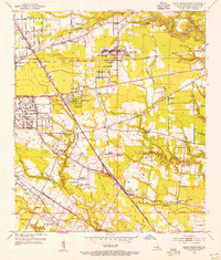
1953 Map of Baton Rouge West
USGS Topo · Published 1954About this map
The Mississippi River creates a stark divide between the industrial and agricultural landscapes of East and West Baton Rouge Parishes in the early 1950s. On the east bank, the urban density of Baton Rouge is evident, centered around the sprawling campus of Louisiana State University and A&M College and landmarks like Capitol Lake and the National Cem. This side of the river is a hub of education and state services, featuring specialized institutions like the School for Deaf and School for Blind.
Find a feature on this map
95 named features on this map. Tap any name to fly to it.
Don’t see what you’re looking for? This feature index may not catch every label — zoom into the map to look around manually.
Map Details
Editions of this 1953 Baton Rouge West Map
This is the sole edition of this map. No revisions or reprints were ever made.
Other maps of this area

1906 · Bayou Sara
USGS Topo · 1:125,000

1908 · Baton Rouge
USGS Topo · 1:62,500

1939 · Zachary
USGS Topo · 1:62,500

1939 · Baton Rouge
USGS Topo · 1:62,500

1940 · Grosse Tete
USGS Topo · 1:62,500

1953 · Plaquemine
USGS Topo · 1:24,000

1953 · Lobdell
USGS Topo · 1:24,000

1953 · Addis
USGS Topo · 1:24,000

1953 · St. Gabriel
USGS Topo · 1:24,000
1953 · Baton Rouge East
USGS Topo · 1:24,000