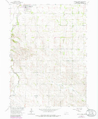
1963 Map of Battle Creek
USGS Topo · Published 1985About this map
Battle Creek anchors this Madison County landscape, situated at the junction of rail and river routes in the early 1960s. The settlement pattern reveals a deeply established rural community defined by its network of denominational landmarks and small district schools. The terrain is bifurcated by the winding course of Battle Creek and the southern reaches of North Taylor Creek, with the surrounding highlands dotted by family-named sites like Allbery Sch and Allbery Cem. This 1963 survey, updated with 1981 aerial data, preserves the locations of several one-room schoolhouses, including School No 22 and School No 88, which served the scattered farmsteads of the Missouri River Basin development area. Genealogists can trace localized burial grounds and parish centers such as Union Cem, Lutheran Ch, and Fairview Ch, marking the spiritual and social hubs of the prairie sections.
Find a feature on this map
15 named features on this map. Tap any name to fly to it.
Don’t see what you’re looking for? This feature index may not catch every label — zoom into the map to look around manually.
Map Details
Editions of this 1963 Battle Creek Map
2 editions found
Other maps of this area

1955 · Sioux City
USGS Topo · 1:250,000

1955 · Fremont
USGS Topo · 1:250,000

1957 · Fremont
USGS Topo · 1:250,000

1958 · Sioux City
USGS Topo · 1:250,000

1958 · Fremont
USGS Topo · 1:250,000

1959 · Sioux City
USGS Topo · 1:250,000

1963 · Madison
USGS Topo · 1:24,000

1963 · Battle Creek
USGS Topo · 1:24,000

1963 · Pierce SE
USGS Topo · 1:24,000

1963 · Emerick
USGS Topo · 1:24,000