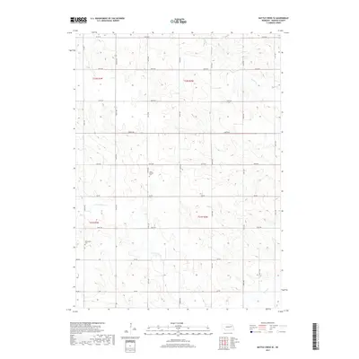
2017 Map of Battle Creek SE
USGS Topo · Published 2017About this map
The agricultural landscape of Madison County is defined by its precise section-line grid and the meandering drainage of Union Cr. This modern survey reveals a landscape largely dedicated to farming, where the rural identity is anchored by historic sites such as Kalamazoo Cem and Green Garden Cem. These small, quiet landmarks serve as critical points of reference for genealogists and local historians, representing the heritage of the families who settled this portion of Nebraska. The terrain is further etched by the paths of Taylor Cr and the N Fork Union Cr, which break the geometric regularity of the county roads. The network of secondary routes, including 824 Rd and 546th Ave, facilitates the movement of grain and livestock across the township lines of t22n r3w and t21n r2w, maintaining the traditional Nebraska farmstead structure into the 21st century.
Find a feature on this map
29 named features on this map. Tap any name to fly to it.
Don’t see what you’re looking for? This feature index may not catch every label — zoom into the map to look around manually.
Map Details
Editions of this 2017 Battle Creek SE Map
This is the sole edition of this map. No revisions or reprints were ever made.
Other maps of this area

1955 · Fremont
USGS Topo · 1:250,000

1957 · Fremont
USGS Topo · 1:250,000

1958 · Fremont
USGS Topo · 1:250,000

1963 · Madison
USGS Topo · 1:24,000

1963 · Battle Creek
USGS Topo · 1:24,000

1963 · Emerick
USGS Topo · 1:24,000
1963 · Enola
USGS Topo · 1:24,000

1963 · Battle Creek SE
USGS Topo · 1:24,000

1963 · Battle Creek SW
USGS Topo · 1:24,000
1966 · Lindsay
USGS Topo · 1:24,000