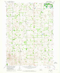
1963 Map of Enola
USGS Topo · Published 1964About this map
Warnerville and Enola serve as the primary hubs in this mid-century Madison County landscape, where the Union Pacific railroad cuts a diagonal line through the central farming precincts. The topography is defined by the broad curves of the Elkhorn River in the northeast and the drainage of Battle Creek to the west. This 1963 field-checked survey highlights a rural infrastructure built around local education and community gatherings, evidenced by the Stange Sch, Reiche Sch, and the Pleasant Valley Community Hall. The presence of the Karl Stefan Airport (Norfolk Municipal) near the northern border signals the era's expanding aviation needs. Small water bodies like Andys Lake and Ueckers Lake are scattered across the terrain, while the Besk Cem in the south provides a point of interest for genealogists tracing early families in the Enola and Fairview townships.
Find a feature on this map
21 named features on this map. Tap any name to fly to it.
Don’t see what you’re looking for? This feature index may not catch every label — zoom into the map to look around manually.
Map Details
Editions of this 1963 Enola Map
2 editions found
Other maps of this area

1955 · Sioux City
USGS Topo · 1:250,000

1955 · Fremont
USGS Topo · 1:250,000

1957 · Fremont
USGS Topo · 1:250,000

1958 · Sioux City
USGS Topo · 1:250,000

1958 · Fremont
USGS Topo · 1:250,000

1959 · Sioux City
USGS Topo · 1:250,000

1963 · Madison
USGS Topo · 1:24,000

1963 · Hoskins
USGS Topo · 1:24,000

1963 · Madison SE
USGS Topo · 1:24,000

1963 · Battle Creek
USGS Topo · 1:24,000