
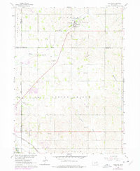
1963 Map of Hoskins
USGS Topo · Published 1964About this map
The village of Hoskins serves as the focal point of this northeast Nebraska landscape, situated at the junction of the Chicago and North Western railroad and several county boundaries. The map documents a rural agrarian structure defined by its local institutions, with several rural schoolhouses including School No 26 and School No 11 dotting the sections between family farms. A distinct concentration of cemeteries, such as the State Hospital Cem, Lutheran Cem, and Zion Cem, provide significant data points for genealogical research in this corridor between the South Branch and the Elkhorn River. Waterways like Spring Branch and Pleasant Run carve through the terrain, while local industry is represented by the Sandpit operations near the river's edge. This 1960s survey illustrates a moment when rural life still revolved around these small-scale church and school districts, shortly before many such schools were consolidated.
Find a feature on this map
25 named features on this map. Tap any name to fly to it.
Don’t see what you’re looking for? This feature index may not catch every label — zoom into the map to look around manually.
Map Details
Editions of this 1963 Hoskins Map
2 editions found
Other maps of this area

1955 · Sioux City
USGS Topo · 1:250,000

1955 · Fremont
USGS Topo · 1:250,000

1957 · Fremont
USGS Topo · 1:250,000

1958 · Sioux City
USGS Topo · 1:250,000

1958 · Fremont
USGS Topo · 1:250,000

1959 · Sioux City
USGS Topo · 1:250,000

1963 · Wayne SW
USGS Topo · 1:24,000

1963 · Norfolk
USGS Topo · 1:24,000

1963 · Winside
USGS Topo · 1:24,000

1963 · Wee Town
USGS Topo · 1:24,000