
1963 Map of Wee Town
USGS Topo · Published 1964About this map
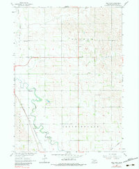
North Fork Elkhorn River meanders through the landscape of Pierce County in the early 1960s, shaping the settlement patterns of this agricultural region. The unincorporated community of Wee Town serves as a central point along a network of section-line roads, surrounded by a high density of rural schoolhouses and cemeteries. Small-scale resource extraction is evident at the Gravel Pit and Sandpits near the riverbanks, supporting local infrastructure. The Chicago and North Western railroad cuts across the southwestern corner, paralleling the river and connecting these rural farmsteads to larger markets. This survey highlights the distribution of community landmarks like St Johns Ch and Koehler Cem, providing a precise record of the social geography before many one-room schoolhouses like School No 20 and Pleasant View Sch were consolidated or removed.
Find a feature on this map
19 named features on this map. Tap any name to fly to it.
Don’t see what you’re looking for? This feature index may not catch every label — zoom into the map to look around manually.
Map Details
Editions of this 1963 Wee Town Map
2 editions found
Other maps of this area

1955 · Sioux City
USGS Topo · 1:250,000

1958 · Sioux City
USGS Topo · 1:250,000

1959 · Sioux City
USGS Topo · 1:250,000

1963 · Hoskins
USGS Topo · 1:24,000

1963 · Pierce SE
USGS Topo · 1:24,000

1963 · Norfolk
USGS Topo · 1:24,000

1963 · Osmond
USGS Topo · 1:24,000
1963 · Pierce
USGS Topo · 1:24,000

1963 · Norfolk NE
USGS Topo · 1:24,000

1971 · Randolph South
USGS Topo · 1:24,000