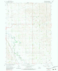
1963 Map of Wee Town
USGS Topo · Published 1983About this map
Agricultural life in Pierce County during the early 1960s is centered around the small settlement of Wee Town and a network of rural school districts. The landscape is defined by the meandering path of the North Fork Elkhorn River and its South Branch, which cut through the terrain alongside the Chicago and North Western railroad line. This period shows a high density of local educational and religious landmarks, including School No 20, Pleasant View Sch, and St Johns Ch. The presence of several family-named and community sites like Koehler Cem and Zion Cem provides a detailed look at the social geography of this Nebraska prairie before major modern shifts in rural infrastructure occurred.
Find a feature on this map
24 named features on this map. Tap any name to fly to it.
Don’t see what you’re looking for? This feature index may not catch every label — zoom into the map to look around manually.
Map Details
Editions of this 1963 Wee Town Map
2 editions found
Other maps of this area

1955 · Sioux City
USGS Topo · 1:250,000

1958 · Sioux City
USGS Topo · 1:250,000

1959 · Sioux City
USGS Topo · 1:250,000

1963 · Hoskins
USGS Topo · 1:24,000

1963 · Pierce SE
USGS Topo · 1:24,000

1963 · Norfolk
USGS Topo · 1:24,000

1963 · Osmond
USGS Topo · 1:24,000

1963 · Wee Town
USGS Topo · 1:24,000
1963 · Pierce
USGS Topo · 1:24,000

1963 · Norfolk NE
USGS Topo · 1:24,000