
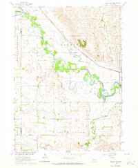
1963 Map of Wayne SW
USGS Topo · Published 1964About this map
Humbug Creek and its various tributaries, including the South Branch Humbug Creek and Payne Creek, carve a rolling landscape of agricultural sections across the Wayne and Stanton County border. In the early 1960s, this rural interior was dotted with localized centers of community life, most notably the settlement at Spurville. The map captures a high density of rural schoolhouses, including School No 12, School No 23, School No 35, and School No 15, reflecting the decentralized education system of the era. Genealogists will find the locations of Bega Cem and Bethlehem Cem helpful for tracing family roots in this corner of Northeast Nebraska. The terrain is further defined by its civil divisions, spanning across the townships of Hancock, Brennan, Dewey, Pilger, and Stanton.
Find a feature on this map
18 named features on this map. Tap any name to fly to it.
Don’t see what you’re looking for? This feature index may not catch every label — zoom into the map to look around manually.
Map Details
Editions of this 1963 Wayne SW Map
This is the sole edition of this map. No revisions or reprints were ever made.
Other maps of this area

1955 · Sioux City
USGS Topo · 1:250,000

1955 · Fremont
USGS Topo · 1:250,000

1957 · Fremont
USGS Topo · 1:250,000

1958 · Sioux City
USGS Topo · 1:250,000

1958 · Fremont
USGS Topo · 1:250,000

1959 · Sioux City
USGS Topo · 1:250,000

1963 · Hoskins
USGS Topo · 1:24,000

1963 · Pilger
USGS Topo · 1:24,000

1963 · Winside
USGS Topo · 1:24,000
1963 · Madison NE
USGS Topo · 1:24,000