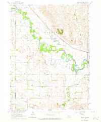
1963 Map of Madison NE
USGS Topo · Published 1964About this map
The Elkhorn River meanders across the rural landscape of Stanton and Madison counties, defining a valley marked by numerous oxbow lakes and wetlands. In the early 1960s, this area was characterized by a dense network of one-room schoolhouses, including School No 21, School No 81, and School No 36, serving the surrounding farmsteads. The Chicago and North Western railroad cuts diagonally through the northern half of the map, following the natural topography north of the river.
Find a feature on this map
19 named features on this map. Tap any name to fly to it.
Don’t see what you’re looking for? This feature index may not catch every label — zoom into the map to look around manually.
Map Details
Editions of this 1963 Madison NE Map
3 editions found
Other maps of this area

1955 · Sioux City
USGS Topo · 1:250,000

1955 · Fremont
USGS Topo · 1:250,000

1957 · Fremont
USGS Topo · 1:250,000

1958 · Sioux City
USGS Topo · 1:250,000

1958 · Fremont
USGS Topo · 1:250,000

1959 · Sioux City
USGS Topo · 1:250,000

1963 · Madison
USGS Topo · 1:24,000

1963 · Hoskins
USGS Topo · 1:24,000

1963 · Madison SE
USGS Topo · 1:24,000

1963 · Wayne SW
USGS Topo · 1:24,000