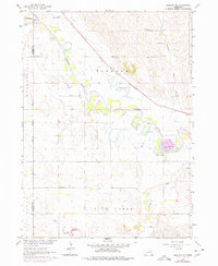
1963 Map of Madison NE
USGS Topo · Published 1977About this map
The North Fork Elkhorn River and Elkhorn River define the winding hydrology of this Nebraska landscape, where the meandering riverbeds have created several oxbow lakes such as Loes Lake, Pillar Lake, and Lehman Lake. The Chicago and North Western railroad cuts a straight diagonal through the terrain, contrasting with the fluid curves of the river system. This 1963 survey, with updates from 1976, documents a rural agricultural network organized around township lines and a strictly numbered school system, including School No 21 and School No 36. Local history and genealogy are anchored by the Pleasant Run Cem and Belz Cem, while the presence of a Sandpit near the river indicates the primary local extractive industry of the mid-20th century. The boundary between Madison and Stanton counties bisects the western half of the sheet, providing a precise look at property and political divisions during this era.
Find a feature on this map
22 named features on this map. Tap any name to fly to it.
Don’t see what you’re looking for? This feature index may not catch every label — zoom into the map to look around manually.
Map Details
Editions of this 1963 Madison NE Map
3 editions found
Other maps of this area

1955 · Sioux City
USGS Topo · 1:250,000

1955 · Fremont
USGS Topo · 1:250,000

1957 · Fremont
USGS Topo · 1:250,000

1958 · Sioux City
USGS Topo · 1:250,000

1958 · Fremont
USGS Topo · 1:250,000

1959 · Sioux City
USGS Topo · 1:250,000

1963 · Madison
USGS Topo · 1:24,000

1963 · Hoskins
USGS Topo · 1:24,000

1963 · Madison SE
USGS Topo · 1:24,000

1963 · Wayne SW
USGS Topo · 1:24,000