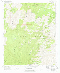
1974 Map of Battle Flat
USGS Topo · Published 1977About this map
Mining operations and rugged high-desert terrain define this mid-1970s survey of the central Bradshaw Mountains. The landscape is dominated by the complex ridges of Tuscumbia Mtn and Brady Butte, where a network of primitive access points like the Senator Highway and various Jeep Trails connect isolated mineral claims. This era shows the region as a working landscape within the Prescott National Forest, characterized by numerous named shafts and prospects.
Find a feature on this map
69 named features on this map. Tap any name to fly to it.
Don’t see what you’re looking for? This feature index may not catch every label — zoom into the map to look around manually.
Map Details
Editions of this 1974 Battle Flat Map
3 editions found
Other maps of this area

1887 · Prescott
USGS Topo · 1:250,000

1892 · Prescott
USGS Topo · 1:250,000

1903 · Bradshaw Mountains
USGS Topo · 1:125,000

1947 · Crown King
USGS Topo · 1:62,500

1947 · Bumblebee
USGS Topo · 1:62,500

1947 · Mayer
USGS Topo · 1:62,500

1947 · Mt. Union
USGS Topo · 1:62,500

1948 · Bumblebee
USGS Topo · 1:63,360

1948 · Crown King
USGS Topo · 1:63,360

1948 · Mt. Union
USGS Topo · 1:63,360