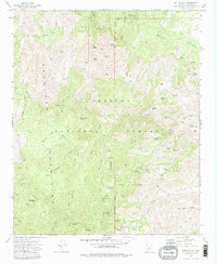
1974 Map of Battle Flat
USGS Topo · Published 1982About this map
The Bradshaw Mountains of Yavapai County define this high-elevation landscape within the Prescott National Forest. In the mid-1970s, the terrain was heavily marked by its mineral wealth, with numerous working and inactive sites including the Tuscumbia Mine, Peck Mine, and De Soto Mine. These locations, often accessed by the historic Senator Highway or more precarious routes like the Pack Trail, tell a story of hard-rock extraction and mountain commerce. The map reveals a sophisticated water management system for a mountain region, cataloging dozens of named tanks such as Brady Butte Tank and Crooked Leg Tank necessary for maintaining livestock or operations. From the high peaks of Tuscumbia Mtn down to the creek beds of Wolf Creek and Middleton Creek, the map serves as a primary record of the Gila and Salt River Meridian's rugged interior.
Find a feature on this map
69 named features on this map. Tap any name to fly to it.
Don’t see what you’re looking for? This feature index may not catch every label — zoom into the map to look around manually.
Map Details
Editions of this 1974 Battle Flat Map
3 editions found
Other maps of this area

1887 · Prescott
USGS Topo · 1:250,000

1892 · Prescott
USGS Topo · 1:250,000

1903 · Bradshaw Mountains
USGS Topo · 1:125,000

1947 · Crown King
USGS Topo · 1:62,500

1947 · Bumblebee
USGS Topo · 1:62,500

1947 · Mayer
USGS Topo · 1:62,500

1947 · Mt. Union
USGS Topo · 1:62,500

1948 · Bumblebee
USGS Topo · 1:63,360

1948 · Crown King
USGS Topo · 1:63,360

1948 · Mt. Union
USGS Topo · 1:63,360