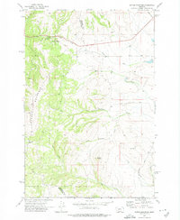
1971 Map of Battle Mountain
USGS Topo · Published 1974About this map
Helena National Forest lands dominate this 1971 topographical survey of the divide between Meagher and Broadwater counties. The landscape is defined by the high ridges of Grassy Mountain and the prominent peak of Battle Mountain, where steep drainage systems like Battle Creek and Faulkner Creek flow toward the lower basins. The presence of the Grass Mountain Ski Area and the Skiway Campground along Castle Fork indicates the area's development as a mid-century recreational destination within the national forest.
Find a feature on this map
19 named features on this map. Tap any name to fly to it.
Don’t see what you’re looking for? This feature index may not catch every label — zoom into the map to look around manually.
Map Details
Editions of this 1971 Battle Mountain Map
This is the sole edition of this map. No revisions or reprints were ever made.
Other maps of this area

1886 · Fort Logan
USGS Topo · 1:250,000

1886 · Little Belt Mts.
USGS Topo · 1:250,000

1894 · Little Belt Mts.
USGS Topo · 1:250,000

1897 · Little Belt Mts.
USGS Topo · 1:250,000

1898 · Little Belt Mts.
USGS Topo · 1:250,000

1902 · Little Belt Mts.
USGS Topo · 1:250,000

1948 · White Sulphur Springs
USGS Topo · 1:250,000

1948 · Sixteen
USGS Topo · 1:24,000

1949 · Maudlow
USGS Topo · 1:62,500
1951 · Black Butte Mountain
USGS Topo · 1:24,000