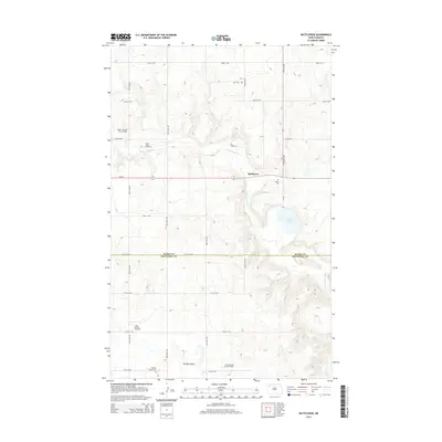
2014 Map of Battleview
USGS Topo · Published 2014About this map
Battleview and the surrounding prairie of Burke and Mountrail counties are defined by a complex grid of rural section roads and an expanding energy infrastructure. The landscape transition from agricultural to industrial is evident through the presence of the North Tioga Oil and Gas Field, the North Tioga Gas Plant, and the Tioga Oil and Gas Field to the south. Local history is anchored at sites like Bethel Cem and Beauty Valley Cem, serving the small settlements of the region. Natural drainage is shaped by the winding course of White Earth Cr, which flows toward the White Earth River, while Sletten Lake provides a notable water feature amidst the topographic contours of the northern plains. This survey captures the coexistence of traditional rural life at Beauty Valley with the modern footprint of North Dakota's oil production.
Find a feature on this map
26 named features on this map. Tap any name to fly to it.
Don’t see what you’re looking for? This feature index may not catch every label — zoom into the map to look around manually.
Map Details
Editions of this 2014 Battleview Map
This is the sole edition of this map. No revisions or reprints were ever made.
Other maps of this area

1953 · Williston
USGS Topo · 1:250,000

1957 · Williston
USGS Topo · 1:250,000

1969 · Ross NW
USGS Topo · 1:24,000

1969 · White Earth
USGS Topo · 1:24,000

1974 · Grubb Lake
USGS Topo · 1:24,000

1974 · McGregor
USGS Topo · 1:24,000

1974 · Grand View
USGS Topo · 1:24,000
1974 · Bush Lake
USGS Topo · 1:24,000

1977 · Powers Lake
USGS Topo · 1:24,000

1978 · Battleview
USGS Topo · 1:24,000