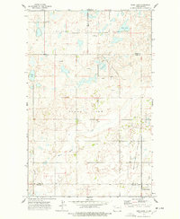
1974 Map of Bush Lake
USGS Topo · Published 1978About this map
Bush Lake and the surrounding prairie of northwestern North Dakota are captured here during a period of active energy development in the mid-1970s. The landscape is defined by a dense concentration of Oil Wells, particularly within the Stoneview Oil and Gas Field and the North Tioga Oil and Gas Field. These industrial features contrast with the established rural infrastructure of the region, including the Town Hall and Our Saviors Ch. The topography is dotted with numerous small wetlands and larger bodies like Nelson Lake and Norman Lake, while White Earth Creek winds through the southern portion of the quadrangle. The map documents the overlap of traditional township boundaries like Harmonius and Stone View with the newer grid of petroleum extraction near the settlement of Battleview.
Find a feature on this map
20 named features on this map. Tap any name to fly to it.
Don’t see what you’re looking for? This feature index may not catch every label — zoom into the map to look around manually.
Map Details
Editions of this 1974 Bush Lake Map
This is the sole edition of this map. No revisions or reprints were ever made.
Other maps of this area

1949 · Columbus SW
USGS Topo · 1:24,000

1949 · Noonan SE
USGS Topo · 1:24,000

1949 · Columbus SE
USGS Topo · 1:24,000

1950 · Columbus
USGS Topo · 1:62,500

1950 · Noonan
USGS Topo · 1:62,500

1953 · Williston
USGS Topo · 1:250,000

1957 · Williston
USGS Topo · 1:250,000

1974 · Hamlet
USGS Topo · 1:24,000

1974 · McGregor
USGS Topo · 1:24,000

1974 · Grand View
USGS Topo · 1:24,000