
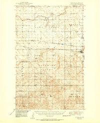
1950 Map of Noonan
USGS Topo · Published 1950About this map
Blooming Valley and the Coalfield terrain characterize this North Dakota landscape along the international border in Divide County. This 1950 era survey captures the intensive rural development of the northern plains, where township lines like Fillmore, Long Creek, and Mentor are punctuated by a dense network of country schoolhouses, including Bluffton Sch No 4, Highland Sch No 1, and McCullough Sch No 2. The regional economy is anchored by the Great Northern and Minneapolis Sault Ste Marie railroads, which served early 20th-century settlements like Noonan, Kermit, and Paulson. A Strip Mine south of Noonan points to the area's subterranean resources, while centers of local life like the Town Hall and Blooming Prairie Ch served the dispersed farmstead population during this period of peak agricultural activity.
Find a feature on this map
40 named features on this map. Tap any name to fly to it.
Don’t see what you’re looking for? This feature index may not catch every label — zoom into the map to look around manually.
Map Details
Editions of this 1950 Noonan Map
2 editions found
Other maps of this area

1947 · Noonan
USGS Topo · 1:24,000

1948 · Alamo N.E.
USGS Topo · 1:24,000

1948 · Crosby
USGS Topo · 1:24,000

1948 · Crosby SE
USGS Topo · 1:24,000

1949 · Columbus SW
USGS Topo · 1:24,000

1949 · Paulson
USGS Topo · 1:24,000

1949 · Atcoal
USGS Topo · 1:24,000

1949 · Noonan SW
USGS Topo · 1:24,000

1949 · Noonan SE
USGS Topo · 1:24,000

1949 · Noonan
USGS Topo · 1:24,000