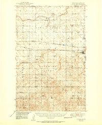
1950 Map of Noonan
USGS Topo · Published 1950About this map
Noonan stands as the primary hub of activity in this northern Divide County landscape, situated just south of the international boundary between Saskatchewan and North Dakota. This era was defined by a robust network of rural institutions, with dozens of one-room schoolhouses like Highland Sch No 1 and Bluffton Sch No 4 serving the agricultural townships. The presence of a Strip Mine southeast of Noonan indicates the early industrial importance of the North Dakota coalfields in this prairie region. Transportation and commerce followed the tracks of the Great Northern and the Minneapolis Sault Ste Marie railroads, which connected smaller sidings and settlements such as Bounty, Juno, and Kermit. Rural spiritual life is anchored by Long Creek Ch and Blooming Prairie Ch, while the winding course of Long Creek provides the primary drainage for the northern plains.
Find a feature on this map
41 named features on this map. Tap any name to fly to it.
Don’t see what you’re looking for? This feature index may not catch every label — zoom into the map to look around manually.
Map Details
Editions of this 1950 Noonan Map
2 editions found

Other maps of this area

1947 · Noonan
USGS Topo · 1:24,000

1948 · Alamo N.E.
USGS Topo · 1:24,000

1948 · Crosby
USGS Topo · 1:24,000

1948 · Crosby SE
USGS Topo · 1:24,000

1949 · Columbus SW
USGS Topo · 1:24,000

1949 · Paulson
USGS Topo · 1:24,000

1949 · Atcoal
USGS Topo · 1:24,000

1949 · Noonan SW
USGS Topo · 1:24,000

1949 · Noonan SE
USGS Topo · 1:24,000

1949 · Noonan
USGS Topo · 1:24,000