
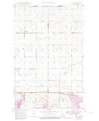
1949 Map of Atcoal
USGS Topo · Published 1949About this map
Strip mines and a sprawling Coal Field dominate the southern landscape of this 1949 survey, marking the heavy industrial character of the borderlands between Divide and Burke Counties. At the intersection of the Minneapolis St Paul and Sault Ste Marie and Great Northern railroads, the settlement of Atcoal serves as a nexus for the region's extractive economy. The map reveals a transition from the industrial activity in the south to a more dispersed agricultural pattern in the north, evidenced by isolated rural schoolhouses such as School No 1, School No 2, and School No 4. The terrain is characterized by numerous small depressions and ponds, with drainage provided by the West Branch of Short Creek. This survey captures the area just south of the Canada United States border, documenting the vital rail sidings and infrastructure, including Strange Siding, that supported mid-century North Dakota coal production.
Find a feature on this map
15 named features on this map. Tap any name to fly to it.
Don’t see what you’re looking for? This feature index may not catch every label — zoom into the map to look around manually.
Map Details
Editions of this 1949 Atcoal Map
2 editions found
Other maps of this area

1947 · Noonan
USGS Topo · 1:24,000

1947 · Columbus
USGS Topo · 1:24,000

1949 · Columbus SW
USGS Topo · 1:24,000

1949 · Columbus
USGS Topo · 1:24,000

1949 · Noonan SE
USGS Topo · 1:24,000

1949 · Columbus SE
USGS Topo · 1:24,000

1949 · Noonan
USGS Topo · 1:24,000

1950 · Columbus
USGS Topo · 1:62,500

1950 · Noonan
USGS Topo · 1:62,500

1953 · Williston
USGS Topo · 1:250,000