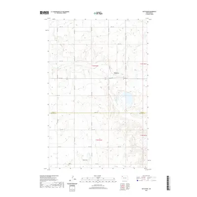
2020 Map of Battleview
USGS Topo · Published 2020About this map
Battleview serves as the central hub of this North Dakota landscape, situated at the intersection of Railway St and 80th St NW. The settlement's orientation is deeply tied to the historical movement of the railroad, which historically dictated the growth of these prairie towns. To the south, the terrain transitions into the distinct depression of Beauty Valley, where the Beauty Valley Cem is located. This area shows the typical grid-based development of the northern plains, where section lines and range markers like t159n r94w define the rural geography. Significant local water features including Sletten Lake and the meandering White Earth Cr provide the primary breaks in the rolling topography, while the Bethel Cem marks a notable point of interest on the eastern edge of the village.
Find a feature on this map
21 named features on this map. Tap any name to fly to it.
Don’t see what you’re looking for? This feature index may not catch every label — zoom into the map to look around manually.
Map Details
Editions of this 2020 Battleview Map
This is the sole edition of this map. No revisions or reprints were ever made.
Other maps of this area

1953 · Williston
USGS Topo · 1:250,000

1957 · Williston
USGS Topo · 1:250,000

1969 · Ross NW
USGS Topo · 1:24,000

1969 · White Earth
USGS Topo · 1:24,000

1974 · Grubb Lake
USGS Topo · 1:24,000

1974 · McGregor
USGS Topo · 1:24,000

1974 · Grand View
USGS Topo · 1:24,000
1974 · Bush Lake
USGS Topo · 1:24,000

1977 · Powers Lake
USGS Topo · 1:24,000

1978 · Battleview
USGS Topo · 1:24,000