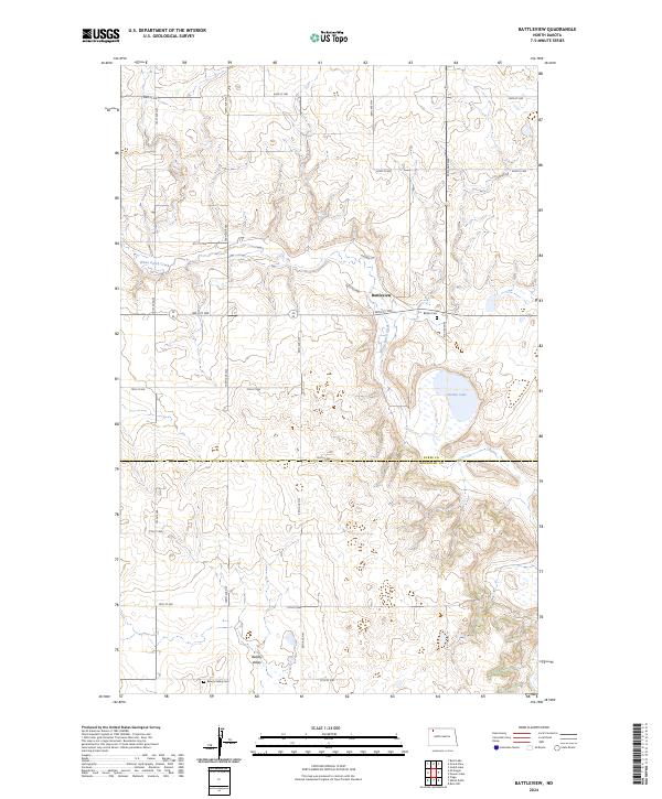
2024 Map of Battleview
USGS Topo · Published 2024About this map
Battleview serves as a central hub in this high plains landscape of northwestern North Dakota, situated where Railway St meets the rural road grid. The geography is defined by the winding course of White Earth Creek and the notable waters of Sletten Lake, set against a backdrop of prairie potholes and agricultural sections. The map reveals a transition across the Burke and Mountrail county line, where the southern portion is largely occupied by the Mountrail County Waterfowl Production Area. Genealogy and local history are anchored by two distinct burial sites: Bethel Cem near the town site and Beauty Valley Cem located further south in the terrain of Beauty Valley. This layout illustrates a traditional prairie settlement pattern, where small communities like Beauty Valley and Battleview provided essential services to a dispersed farming population.
Find a feature on this map
28 named features on this map. Tap any name to fly to it.
Don’t see what you’re looking for? This feature index may not catch every label — zoom into the map to look around manually.
Map Details
Editions of this 2024 Battleview Map
This is the sole edition of this map. No revisions or reprints were ever made.
Other maps of this area

1953 · Williston
USGS Topo · 1:250,000

1957 · Williston
USGS Topo · 1:250,000

1969 · Ross NW
USGS Topo · 1:24,000

1969 · White Earth
USGS Topo · 1:24,000

1974 · Grubb Lake
USGS Topo · 1:24,000

1974 · McGregor
USGS Topo · 1:24,000

1974 · Grand View
USGS Topo · 1:24,000
1974 · Bush Lake
USGS Topo · 1:24,000

1977 · Powers Lake
USGS Topo · 1:24,000

1978 · Battleview
USGS Topo · 1:24,000