
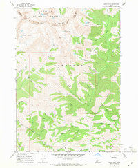
1967 Map of Baugh Creek SW
USGS Topo · Published 1971About this map
Sawtooth National Forest dominates this Idaho landscape, characterized by a complex drainage network flowing through deep canyons and gulches. The terrain is defined by steep ridges and watercourses like Baugh Creek, Quigley Creek, and the aptly named Slaughterhouse Creek. Human activity is concentrated around extraction and basic access, evidenced by unnamed Mines located in the central hills and a lonely Cabin near Cove Creek. Transport in this era relied on a sparse network of paths, including a dedicated Driveway in the north and various trails and jeep trails that navigate the difficult topography. The presence of The Narrows suggests a bottleneck in the local geography, likely influencing the placement of these early routes. This survey provides a record of the remote back-country before modern expansion, capturing the area when natural springs were the primary landmarks for those traversing the mountains.
Find a feature on this map
22 named features on this map. Tap any name to fly to it.
Don’t see what you’re looking for? This feature index may not catch every label — zoom into the map to look around manually.
Map Details
Editions of this 1967 Baugh Creek SW Map
This is the sole edition of this map. No revisions or reprints were ever made.
Other maps of this area

1895 · Hailey
USGS Topo · 1:125,000

1897 · Hailey
USGS Topo · 1:125,000

1955 · Hailey
USGS Topo · 1:250,000

1957 · Bellevue
USGS Topo · 1:62,500

1957 · Bellevue
USGS Topo · 1:24,000

1959 · Hailey
USGS Topo · 1:250,000

1962 · Hailey
USGS Topo · 1:250,000

1967 · Baugh Creek
USGS Topo · 1:24,000

1967 · Sun Valley
USGS Topo · 1:24,000
1967 · Grays Peak
USGS Topo · 1:24,000