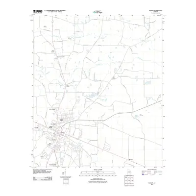
2011 Map of Baxley
USGS Topo · Published 2011About this map
The Georgia city of Baxley serves as the central hub of this 2011 survey, showing a landscape defined by organized housing developments and agricultural roots. Neighborhoods such as Baker Homes, Warrick Homes, Clay Homes, and Speer Homes radiate from the core, while outskirts like Shady Acres and Cook Heights mark the town's expansion. The rural character of Appling County remains evident in the numerous family and community burial grounds scattered across the terrain, including Sellers Cemetery, Carter Cemetery, and the Appling Memorial Cemetery.
Find a feature on this map
80 named features on this map. Tap any name to fly to it.
Don’t see what you’re looking for? This feature index may not catch every label — zoom into the map to look around manually.
Map Details
Editions of this 2011 Baxley Map
This is the sole edition of this map. No revisions or reprints were ever made.
Other maps of this area

1953 · Waycross
USGS Topo · 1:250,000

1958 · Waycross
USGS Topo · 1:250,000
1970 · Altamaha
USGS Topo · 1:24,000

1970 · Baxley NE
USGS Topo · 1:24,000
1970 · Altamaha SW
USGS Topo · 1:24,000

1970 · Pine Grove
USGS Topo · 1:24,000
1970 · Grays Landing
USGS Topo · 1:24,000

1970 · Baxley
USGS Topo · 1:24,000

1971 · Surrency
USGS Topo · 1:24,000

1971 · Alma NW
USGS Topo · 1:24,000