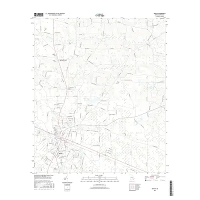
2017 Map of Baxley
USGS Topo · Published 2017About this map
Baxley serves as the primary hub of this south Georgia landscape, showcasing a dense grid of streets and residential development surrounded by a network of family-named roads and rural cemeteries. The geography is defined by the slow movement of Little Tenmile Cr and Tenmile Cr, which wind through low-lying areas punctuated by several small water bodies like Dunns Lake and Miles Lake. This map reveals a community deeply rooted in its local geography, with numerous roads such as Sellers Cemetery Rd and Pleasant Hill Church Rd leading to established landmarks.
Find a feature on this map
170 named features on this map. Tap any name to fly to it.
Don’t see what you’re looking for? This feature index may not catch every label — zoom into the map to look around manually.
Map Details
Editions of this 2017 Baxley Map
This is the sole edition of this map. No revisions or reprints were ever made.
Other maps of this area

1953 · Waycross
USGS Topo · 1:250,000

1958 · Waycross
USGS Topo · 1:250,000
1970 · Altamaha
USGS Topo · 1:24,000

1970 · Baxley NE
USGS Topo · 1:24,000
1970 · Altamaha SW
USGS Topo · 1:24,000

1970 · Pine Grove
USGS Topo · 1:24,000
1970 · Grays Landing
USGS Topo · 1:24,000

1970 · Baxley
USGS Topo · 1:24,000

1971 · Surrency
USGS Topo · 1:24,000

1971 · Alma NW
USGS Topo · 1:24,000