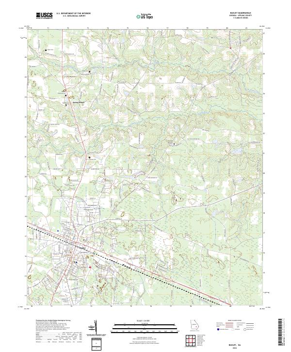
2024 Map of Baxley
USGS Topo · Published 2024About this map
Baxley serves as the seat of Appling County, organized around the Appling County Courthouse and a grid of residential and industrial streets. This contemporary survey by the U.S. Geological Survey documents the town's modern footprint alongside the established rural landscape of southeast Georgia. North of the city center, the terrain is defined by the drainage basins of Little Tenmile Creek and Tenmile Creek, where long-standing family and community sites like Sellers Cemetery and Carter Cemetery sit among timberlands and agricultural plots. The map reveals a dense network of local roads named for prominent area families, including Hilton Baxley Road and Jimmy Crosby Road, illustrating the deep-rooted genealogical ties in the region. To the north, the small settlement of Spring Branch remains a distinct marker on the landscape, flanked by the Appling Memorial Cemetery.
Find a feature on this map
163 named features on this map. Tap any name to fly to it.
Don’t see what you’re looking for? This feature index may not catch every label — zoom into the map to look around manually.
Map Details
Editions of this 2024 Baxley Map
This is the sole edition of this map. No revisions or reprints were ever made.
Other maps of this area

1953 · Waycross
USGS Topo · 1:250,000

1958 · Waycross
USGS Topo · 1:250,000
1970 · Altamaha
USGS Topo · 1:24,000

1970 · Baxley NE
USGS Topo · 1:24,000
1970 · Altamaha SW
USGS Topo · 1:24,000

1970 · Pine Grove
USGS Topo · 1:24,000
1970 · Grays Landing
USGS Topo · 1:24,000

1970 · Baxley
USGS Topo · 1:24,000

1971 · Surrency
USGS Topo · 1:24,000

1971 · Alma NW
USGS Topo · 1:24,000