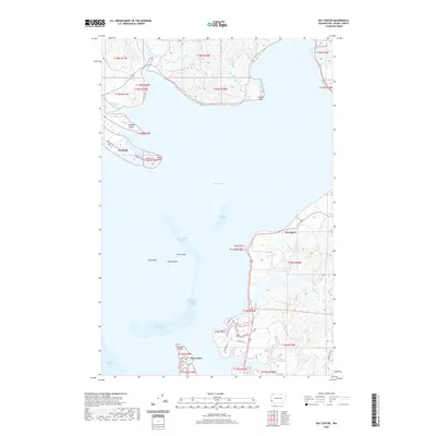
2020 Map of Bay Center
USGS Topo · Published 2020About this map
Willapa Bay dominates this coastal landscape, where the tides shape a complex network of channels and mudflats. The primary settlements of Tokeland and Bay Center anchor the western and southern reaches of the quadrangle, connected to the mainland via Tokeland RD and Wilson LN. Historically significant coastal points like Toke Point, Goose Point, and Stony Point mark the transition from land to water, while the interior is defined by numerous sloughs and creeks such as Teal Duck Slough and Freshwater Creek.
Find a feature on this map
36 named features on this map. Tap any name to fly to it.
Don’t see what you’re looking for? This feature index may not catch every label — zoom into the map to look around manually.
Map Details
Editions of this 2020 Bay Center Map
This is the sole edition of this map. No revisions or reprints were ever made.
Other maps of this area

1938 · Cape Shoalwater
USGS Topo · 1:62,500

1938 · South Bend
USGS Topo · 1:62,500

1940 · South Bend
USGS Topo · 1:62,500

1941 · Grayland
USGS Topo · 1:62,500

1943 · Copalis Beach
USGS Topo · 1:250,000

1951 · Copalis Beach
USGS Topo · 1:250,000

1953 · Hoquiam
USGS Topo · 1:250,000
1955 · North Nemah
USGS Topo · 1:24,000

1955 · Aberdeen SE
USGS Topo · 1:24,000
1956 · North Cove
USGS Topo · 1:24,000