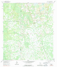
1984 Map of Bay Lake
USGS Topo · Published 1989About this map
The Withlacoochee State Forest dominates this Central Florida landscape, where the border between Sumter and Lake Counties meets amidst a complex network of wetlands. In the early 1960s, the rural character of this region was defined by its water features and forestry access, anchored by the community at Bay Lake and the Bay Lake Church. The terrain is marked by seasonal water bodies and marshes like Gator Hole, Mill Pond, and the Devils Creek Swamp. Industrial and transport infrastructure is represented by the Seaboard Air Line railroad corridor, which cuts across the marshy lowlands of the Bay of Slough. A grid of managed forestry routes, including North Grade Road and Center Grade Road, provides a glimpse into the mid-century timber and land management patterns of the Florida interior.
Find a feature on this map
14 named features on this map. Tap any name to fly to it.
Don’t see what you’re looking for? This feature index may not catch every label — zoom into the map to look around manually.
Map Details
Editions of this 1984 Bay Lake Map
This is the sole edition of this map. No revisions or reprints were ever made.
Other maps of this area

1955 · Plant City
USGS Topo · 1:250,000

1955 · Orlando
USGS Topo · 1:250,000

1957 · Orlando
USGS Topo · 1:250,000

1958 · Orlando
USGS Topo · 1:250,000

1958 · Plant City
USGS Topo · 1:250,000

1958 · Webster
USGS Topo · 1:24,000

1959 · Plant City
USGS Topo · 1:250,000

1959 · Lake Nellie
USGS Topo · 1:24,000

1959 · Poyner
USGS Topo · 1:24,000

1960 · Branchborough
USGS Topo · 1:24,000