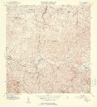
1952 Map of Bayaney
USGS Topo · Published 1952About this map
Bayaney and the surrounding rural barrios of northern Puerto Rico appear here in the early 1950s, a period of transition for the island's interior. This topography, mapped by plane-table surveys in 1943 and revised in 1952, reveals a landscape of dense hills and winding river valleys, including the Rio Camuy and Rio Guajataca. The settlement pattern is defined by a network of rural schools, such as the Escuela Theodore Roosevelt and Escuela Segunda Unidad de Bayaney, reflecting the community-centered infrastructure of the mid-century era.
Find a feature on this map
48 named features on this map. Tap any name to fly to it.
Don’t see what you’re looking for? This feature index may not catch every label — zoom into the map to look around manually.
Map Details
Editions of this 1952 Bayaney Map
2 editions found
Other maps of this area

1938 · Camuy
USGS Topo · 1:20,000

1938 · San Sebastian
USGS Topo · 1:20,000

1938 · Quebradillas
USGS Topo · 1:20,000

1941 · San Sebastian
USGS Topo · 1:30,000

1942 · Arecibo
USGS Topo · 1:30,000

1942 · Camuy
USGS Topo · 1:30,000

1946 · Maricao
USGS Topo · 1:30,000

1946 · Utuado
USGS Topo · 1:30,000

1946 · Bayaney
USGS Topo · 1:30,000

1946 · Monte Guilarte
USGS Topo · 1:30,000
Featured Places
- Alturas de Quebrada, Camuy
- Sector Las Cuarenta, Hatillo
- Parcelas Miria, Lares
- Sector El Calvario, Utuado
- Sector Los Cuevas, Utuado