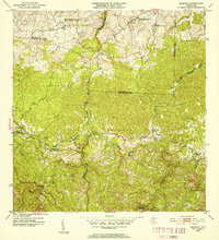
1952 Map of Bayaney
USGS Topo · Published 1952About this map
The rugged interior topography of north-central Puerto Rico is depicted in this 1952 revision of 1943 surveys. The landscape is dominated by the complex drainage systems of the Rio Camuy, Rio Guajataca, and Rio Tanama, which carve through the limestone karst and high terrain of barrios like Aibonito and Callejones. The settlement pattern follows the serpentine mountain roads, centered on the communities of Bayaney and Angeles. A notable density of educational sites, such as the Escuela Theodore Roosevelt and the Escuela Intermedia Santiago R. Palmer, underscores the local commitment to public works under the administration of Secretary Roberto Sanchez Vilella. These schools, often the focal point of rural barrios like Caguana, provide vital landmarks for genealogists tracing family roots in the mountainous Pueblo district and surrounding municipalities.
Find a feature on this map
39 named features on this map. Tap any name to fly to it.
Don’t see what you’re looking for? This feature index may not catch every label — zoom into the map to look around manually.
Map Details
Editions of this 1952 Bayaney Map
2 editions found
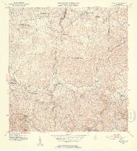
Other maps of this area

1938 · Camuy
USGS Topo · 1:20,000

1938 · San Sebastian
USGS Topo · 1:20,000

1938 · Quebradillas
USGS Topo · 1:20,000

1941 · San Sebastian
USGS Topo · 1:30,000

1942 · Arecibo
USGS Topo · 1:30,000

1942 · Camuy
USGS Topo · 1:30,000

1946 · Maricao
USGS Topo · 1:30,000

1946 · Utuado
USGS Topo · 1:30,000

1946 · Bayaney
USGS Topo · 1:30,000

1946 · Monte Guilarte
USGS Topo · 1:30,000
Featured Places
- Sector El Calvario, Utuado
- Parcelas Miria, Lares
- Sector Los Cuevas, Utuado
- Sector Las Cuarenta, Hatillo
- Sector Los Santiagos, Lares