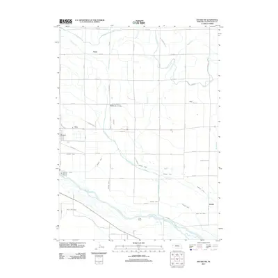
2011 Map of Bayard SW
USGS Topo · Published 2011About this map
The North Platte River defines the southern reach of this Nebraska landscape, where the braided riverbed surrounds the prominent Long Island. This 2011 survey reveals an intricate irrigation network essential to the High Plains, featuring the Tri-State Canal and Ninemile Canal cutting across the terrain to support local agriculture. Small communities and rail-side points like Minatare, Baxter, and Tony are connected by a rigid grid of county roads, illustrating the systematic land division of Scotts Bluff County.
Find a feature on this map
44 named features on this map. Tap any name to fly to it.
Don’t see what you’re looking for? This feature index may not catch every label — zoom into the map to look around manually.
Map Details
Editions of this 2011 Bayard SW Map
This is the sole edition of this map. No revisions or reprints were ever made.
Other maps of this area

1898 · Scotts Bluff
USGS Topo · 1:125,000

1898 · Camp Clarke
USGS Topo · 1:125,000

1954 · Scottsbluff
USGS Topo · 1:250,000

1958 · Scottsbluff
USGS Topo · 1:250,000

1965 · Minatare
USGS Topo · 1:24,000

1965 · Bayard
USGS Topo · 1:24,000
1965 · Bayard NE
USGS Topo · 1:24,000

1965 · South Bayard
USGS Topo · 1:24,000
1965 · Lake Alice
USGS Topo · 1:24,000

1965 · Bayard SW
USGS Topo · 1:24,000