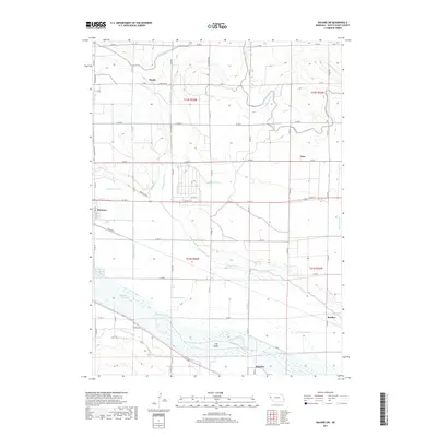
2017 Map of Bayard SW
USGS Topo · Published 2017About this map
North Platte River braided channels dominate this landscape in western Nebraska, defining the irrigation-dependent agriculture of Scotts Bluff County. The intricate web of engineered waterways, including the Tri-State Canal, Ninemile Canal, and Castle Rock Canal, illustrates the region's reliance on diverting river water to support the surrounding plains. Small railroad-aligned settlements and rural hubs like Minatare and McGrew anchor the transport network, while family-named locales such as Baxter, Tony, and Bradley mark the transition between the valley floor and the higher rangeland. The presence of Long Island within the river corridor and numerous drainage features like the Moffat Drain and Minatare Drain reveal a highly modified riparian environment designed for maximum agricultural utility.
Find a feature on this map
37 named features on this map. Tap any name to fly to it.
Don’t see what you’re looking for? This feature index may not catch every label — zoom into the map to look around manually.
Map Details
Editions of this 2017 Bayard SW Map
This is the sole edition of this map. No revisions or reprints were ever made.
Other maps of this area

1898 · Scotts Bluff
USGS Topo · 1:125,000

1898 · Camp Clarke
USGS Topo · 1:125,000

1954 · Scottsbluff
USGS Topo · 1:250,000

1958 · Scottsbluff
USGS Topo · 1:250,000

1965 · Minatare
USGS Topo · 1:24,000

1965 · Bayard
USGS Topo · 1:24,000
1965 · Bayard NE
USGS Topo · 1:24,000

1965 · South Bayard
USGS Topo · 1:24,000
1965 · Lake Alice
USGS Topo · 1:24,000

1965 · Bayard SW
USGS Topo · 1:24,000