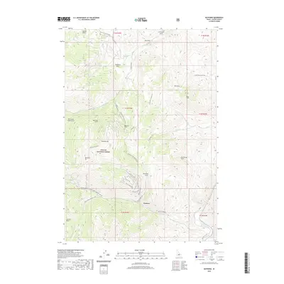
2020 Map of Bayhorse
USGS Topo · Published 2020About this map
Bayhorse is the central point of interest in this high-elevation terrain within the Challis National Forest. The landscape is defined by its deep mining heritage, which is evidenced by the concentrated network of industrial sites and trails including the Pacific Mines, Keystone, and the Lombard mine. These operations are linked by specialized transport routes such as the Pacific Mines Trail and the Sherman Lode, which traverse the steep slopes between Ramshorn Mtn and Keystone Mtn. To the southeast, the Salmon River cuts through the lower elevations, while various gulches like Beardsley Gulch and Merrimac Gulch drain the surrounding peaks. The mapping of routes like the Bayhorse Rd and specialized seasonal paths such as Keystone Gulch Road (Snow) reflects the challenges of accessing these mountain deposits throughout the year.
Find a feature on this map
48 named features on this map. Tap any name to fly to it.
Don’t see what you’re looking for? This feature index may not catch every label — zoom into the map to look around manually.
Map Details
Editions of this 2020 Bayhorse Map
This is the sole edition of this map. No revisions or reprints were ever made.
Other maps of this area

1929 · Bayhorse
USGS Topo · 1:125,000

1956 · Challis
USGS Topo · 1:62,500

1956 · Twin Peaks
USGS Topo · 1:62,500

1957 · Challis
USGS Topo · 1:250,000

1960 · Challis
USGS Topo · 1:250,000

1963 · Challis
USGS Topo · 1:250,000

1963 · Bald Mountain
USGS Topo · 1:24,000

1963 · Bayhorse Lake
USGS Topo · 1:24,000

1963 · Bayhorse
USGS Topo · 1:24,000

1963 · Clayton
USGS Topo · 1:24,000