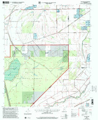
2000 Map of Bayland
USGS Topo · Published 2002About this map
The Delta National Forest dominates this landscape in the Mississippi Delta, where the intersection of Sharkey and Yazoo counties meets a complex network of bayous and water management features. The area around Bayland and Silver Creek is defined by an extensive system of Levees and the Spoil Bank, reflecting the region's managed hydrology at the turn of the millennium. These engineering works stand alongside older points of interest such as the Cem near the creek and the small settlement at Colby.
Find a feature on this map
18 named features on this map. Tap any name to fly to it.
Don’t see what you’re looking for? This feature index may not catch every label — zoom into the map to look around manually.
Map Details
Editions of this 2000 Bayland Map
This is the sole edition of this map. No revisions or reprints were ever made.
Other maps of this area

1939 · Lorenzen
USGS Topo · 1:62,500

1939 · Swan Lake
USGS Topo · 1:62,500

1940 · Auter
USGS Topo · 1:62,500

1953 · Greenwood
USGS Topo · 1:250,000

1955 · Jackson
USGS Topo · 1:250,000

1956 · Greenwood
USGS Topo · 1:250,000

1961 · Jackson
USGS Topo · 1:250,000

1961 · Bayland
USGS Topo · 1:62,500

1962 · Jackson
USGS Topo · 1:250,000

1964 · Lorenzen
USGS Topo · 1:62,500