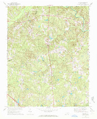
1967 Map of Bayleaf
USGS Topo · Published 1972About this map
Wake-Minster and Bayleaf anchor this northern Wake County landscape in the late 1960s, prior to the large-scale suburban expansion of the Raleigh area. The terrain is defined by a dense network of creek valleys, including Upper Barton Creek, Hare Snipe Creek, and Turkey Creek, which flow toward the Neuse River in the northeast. Rural life is evidenced by numerous country churches such as Cedar Grove Ch, Chestnut Grove Ch, and Pleasant Union Ch, each serving as a focal point for the surrounding farmsteads.
Find a feature on this map
36 named features on this map. Tap any name to fly to it.
Don’t see what you’re looking for? This feature index may not catch every label — zoom into the map to look around manually.
Map Details
Editions of this 1967 Bayleaf Map
4 editions found
Other maps of this area

1943 · Durham South
USGS Topo · 1:62,500

1943 · Raleigh
USGS Topo · 1:62,500

1943 · Creedmoor
USGS Topo · 1:62,500

1944 · Creedmoor
USGS Topo · 1:62,500

1951 · Raleigh
USGS Topo · 1:62,500

1951 · Durham South
USGS Topo · 1:62,500

1951 · Durham North
USGS Topo · 1:62,500

1953 · Raleigh
USGS Topo · 1:250,000

1953 · Greensboro
USGS Topo · 1:250,000

1954 · Greensboro
USGS Topo · 1:250,000