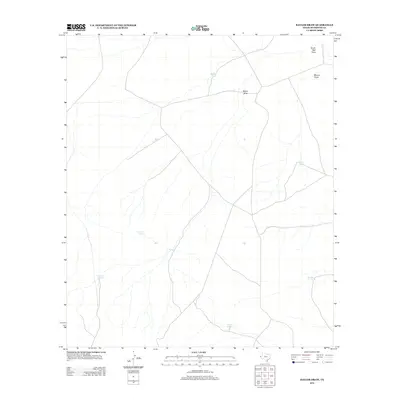
2012 Map of Baylor Draw
USGS Topo · Published 2012About this map
Arid ranchlands and ephemeral watercourses define this portion of Hudspeth County, where the landscape is marked by the critical infrastructure of western cattle operations. Drainage systems like Baylor Draw, Blanco Draw, and South Well Draw carve paths through the terrain, though they remain dry for much of the year. To support livestock in this desert environment, numerous catchments and reservoirs have been established, many bearing names that reflect the local heritage or topography. Water sources such as Double Tanks, Preacher Tank, and Big Moon Tank serve as vital landmarks for those tracking land use and family ranching history in the Trans-Pecos. The network of secondary roads and trails shown on this sheet illustrates the vast distances between these isolated watering points like Corner Tank and N Tank, highlighting the survival strategies required in the high desert of West Texas.
Find a feature on this map
10 named features on this map. Tap any name to fly to it.
Don’t see what you’re looking for? This feature index may not catch every label — zoom into the map to look around manually.
Map Details
Editions of this 2012 Baylor Draw Map
This is the sole edition of this map. No revisions or reprints were ever made.
Other maps of this area

1894 · Fort Hancock
USGS Topo · 1:125,000

1895 · Sierra Blanca
USGS Topo · 1:125,000

1903 · Cerro Alto
USGS Topo · 1:125,000

1943 · Tepee Butte
USGS Topo · 1:62,500

1943 · Finlay Mountains
USGS Topo · 1:62,500

1948 · Triple Hill
USGS Topo · 1:62,500

1951 · Red Hills
USGS Topo · 1:62,500

1954 · Van Horn
USGS Topo · 1:250,000

1958 · Van Horn
USGS Topo · 1:250,000
1977 · Diablo Canyon East
USGS Topo · 1:24,000