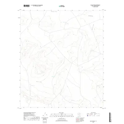
2019 Map of Baylor Draw
USGS Topo · Published 2019About this map
Baylor Draw and Blanco Draw cut through this arid landscape of western Texas, defining the drainage patterns of Hudspeth County. The terrain is characterized by a sparse but essential network of water management features, including several named stock tanks that suggest a history of ranching and livestock movement in this high-desert environment. Notable catchments such as Preacher Tank, Big Moon Tank, and Double Tanks are scattered across the quadrangle, serving as vital landmarks and water sources in an otherwise dry expanse. The map also captures the upper reaches of Mohawk Draw and South Well Draw, illustrating the complex system of ephemeral washes that shape the local topography. This collection of family-named or descriptively-named tanks and draws provides a look at the infrastructure required to sustain life and agriculture in this corner of the Trans-Pecos.
Find a feature on this map
11 named features on this map. Tap any name to fly to it.
Don’t see what you’re looking for? This feature index may not catch every label — zoom into the map to look around manually.
Map Details
Editions of this 2019 Baylor Draw Map
This is the sole edition of this map. No revisions or reprints were ever made.
Other maps of this area

1894 · Fort Hancock
USGS Topo · 1:125,000

1895 · Sierra Blanca
USGS Topo · 1:125,000

1903 · Cerro Alto
USGS Topo · 1:125,000

1943 · Tepee Butte
USGS Topo · 1:62,500

1943 · Finlay Mountains
USGS Topo · 1:62,500

1948 · Triple Hill
USGS Topo · 1:62,500

1951 · Red Hills
USGS Topo · 1:62,500

1954 · Van Horn
USGS Topo · 1:250,000

1958 · Van Horn
USGS Topo · 1:250,000
1977 · Diablo Canyon East
USGS Topo · 1:24,000