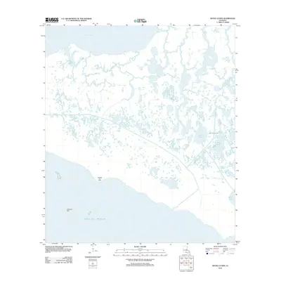
2012 Map of Bayou Lucien
USGS Topo · Published 2012About this map
Vermillion Bay and the Gulf of Mexico define this coastal stretch of Iberia Parish, where the land dissolves into a complex network of marshes and tidal channels. The landscape is dominated by interior water bodies such as Lucien Lake and Long Lake, along with specialized environments like Diamond Reef. A clear sign of the region's economic intersection with its environment is the Lake Ferme Gas Field, situated near the shoreline of Lake Ferme. The lack of named roads or settlements highlights the isolation of this wetland region, where geographical landmarks like Grosse Isle Point provide essential orientation for navigation. This map documents a fragile coastal ecosystem where the distinction between land and water is constantly shifting, shaped by the waters of Big Charles Bayou and the surrounding saltwater bays.
Find a feature on this map
10 named features on this map. Tap any name to fly to it.
Don’t see what you’re looking for? This feature index may not catch every label — zoom into the map to look around manually.
Map Details
Editions of this 2012 Bayou Lucien Map
This is the sole edition of this map. No revisions or reprints were ever made.
Other maps of this area

1932 · Bayou Blanc
USGS Topo · 1:31,680

1945 · New Orleans
USGS Topo · 1:250,000

1946 · Redfish Point NE
USGS Topo · 1:31,680

1946 · Redfish Point SE
USGS Topo · 1:31,680
1948 · Bayou Blanc
USGS Topo · 1:24,000

1948 · Cypremort Point
USGS Topo · 1:24,000

1949 · Cypremort Pt
USGS Topo · 1:31,680

1949 · Bayou Lucien
USGS Topo · 1:31,680
1951 · Mound Point
USGS Topo · 1:24,000
1951 · Bayou Lucien
USGS Topo · 1:24,000